

A Georgia map helps readers understand the location of major cities, counties, highways, rivers, lakes, mountains, and coastal areas across the state. Georgia lies in the southeastern United States and has a diverse landscape that stretches from the Blue Ridge Mountains in the north to the Atlantic coastline in the east. Maps are useful for travelers, students, residents, researchers, and anyone who wants a clearer picture of the state’s geography.
Different maps provide different types of information. A road map focuses on highways and driving routes, while a county map highlights administrative boundaries and local areas. Physical maps show mountains, rivers, elevations, and other natural features. Travelers may prefer maps containing attractions and major cities, while students may need detailed geographic information. Using several map types together provides a more complete understanding of Georgia and its important regional connections.
Where Georgia Is Located in the United States
Georgia is located in the southeastern region of the United States. It shares borders with Florida to the south, Alabama to the west, Tennessee and North Carolina to the north, and South Carolina to the northeast. The Atlantic Ocean forms part of Georgia’s eastern boundary. This location gives the state important transportation connections with Florida, the Carolinas, the Gulf region, and other destinations throughout the American Southeast.
Atlanta, the state capital, is located in north-central Georgia and serves as the largest metropolitan center. From Atlanta, highways extend toward Tennessee, Alabama, South Carolina, Florida, and Georgia’s Atlantic coast. The state’s location has helped it become an important transportation and business hub. Understanding Georgia’s position on a national map also makes it easier to plan interstate travel and identify major routes connecting the state with neighboring regions.
Georgia Map With Major Cities and Towns
A Georgia map with cities usually highlights Atlanta, Augusta, Columbus, Macon, Savannah, Athens, Albany, Valdosta, Warner Robins, Gainesville, and other important population centers. Atlanta dominates the state’s urban landscape and serves as a major center for transportation, business, entertainment, education, and government. Other cities have their own regional importance, creating a network of communities spread throughout northern, central, southern, and coastal Georgia.
Savannah is located near the Atlantic coast and is known for its historic character, while Augusta sits near the South Carolina border. Macon occupies an important position in central Georgia, and Columbus lies near the Alabama state line. Athens is northeast of Atlanta and is closely associated with the University of Georgia. Mapping these cities helps travelers understand distances, regional identities, and the routes connecting Georgia’s most important urban destinations.
Georgia Roads, Interstates, and Highways
Georgia has an extensive highway network that connects its cities with neighboring states and major destinations across the Southeast. Important interstate highways include I-75, I-85, I-20, I-16, I-95, and I-285. Interstate 75 travels through Atlanta, Macon, and southern Georgia, making it one of the state’s most important north-south routes. Interstate 85 connects Atlanta with Alabama and continues northeast toward South Carolina and beyond.
Interstate 20 crosses Georgia from west to east through the Atlanta area before continuing toward Augusta. I-16 provides a major connection between Macon and Savannah, while I-95 follows the Atlantic coastal corridor. Around metropolitan Atlanta, I-285 forms a major beltway used by local and long-distance traffic. A Georgia map with roads can therefore be especially useful for planning road trips, estimating routes, and understanding how different regions are connected.
Georgia County Map
Georgia is divided into 159 counties, making county boundaries an important feature on detailed state maps. A Georgia county map helps users identify local government areas, communities, property locations, school districts, and regional boundaries. Some counties contain large urban populations, while others are predominantly rural. Understanding county locations can be especially helpful for relocation research, real estate, education, public services, and local travel planning throughout the state.
Fulton County contains much of Atlanta, while DeKalb, Cobb, Gwinnett, and Clayton counties are also closely connected to the metropolitan area. Chatham County includes Savannah, Richmond County includes much of Augusta, and Muscogee County is associated with Columbus. Bibb County includes Macon. Because cities and counties sometimes overlap in complex ways, county maps provide geographic context that general city maps may not show clearly enough.
North Georgia, Central Georgia, and South Georgia
Georgia can be understood through several broad geographic regions, each with different landscapes, communities, and travel experiences. North Georgia contains mountainous terrain, foothills, forests, and communities such as Dalton, Rome, Gainesville, and Blue Ridge. Metropolitan Atlanta also occupies a major portion of northern Georgia. The region attracts visitors interested in mountain scenery, hiking, lakes, small towns, vineyards, and outdoor recreation throughout the year.
Central Georgia includes cities such as Macon and Warner Robins and serves as a transition between the northern hills and the flatter landscapes farther south. South Georgia includes Albany, Valdosta, and numerous agricultural communities. Coastal Georgia contains Savannah, Brunswick, marshlands, beaches, and barrier islands. A regional Georgia map can help travelers compare these areas and understand how climate, terrain, transportation, and local culture change across the state.
Georgia Mountains, Rivers, and Lakes
Northern Georgia contains part of the Blue Ridge Mountains, giving the state some of its highest elevations and most dramatic natural scenery. Brasstown Bald is the highest point in Georgia and offers wide views across the surrounding mountain landscape. The northern region also contains forests, waterfalls, hiking trails, and scenic drives. These features make physical maps particularly useful for visitors planning outdoor trips in the mountainous part of the state.
Georgia also contains important rivers including the Chattahoochee, Savannah, Flint, Ocmulgee, and Altamaha. These waterways influence recreation, ecosystems, agriculture, and regional development. Numerous lakes and reservoirs provide opportunities for boating, fishing, swimming, and camping. A detailed Georgia map showing rivers and lakes can help outdoor travelers plan activities while also illustrating how water systems connect different parts of the state from the mountains to the coastal plain.
Georgia Atlantic Coast and Barrier Islands
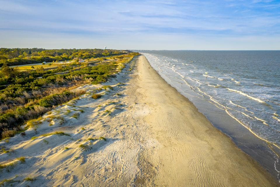
Georgia’s Atlantic coastline gives the state another distinct geographic region. Coastal areas feature beaches, tidal creeks, salt marshes, historic communities, wildlife habitats, and barrier islands. Savannah is one of the best-known cities in this part of the state and serves as an important cultural and tourism center. Farther south, Brunswick provides access to several popular islands and coastal destinations that attract visitors throughout the year.
Well-known barrier islands include Cumberland Island, Jekyll Island, and St. Simons Island. Each offers different combinations of beaches, historic sites, nature, recreation, and wildlife. Coastal maps can help travelers locate islands, bridges, highways, waterways, and nearby communities. The landscape differs significantly from the mountains of North Georgia, showing how geographically diverse the state is within a relatively manageable distance from one region to another.
Georgia Map for Road Trips and Travel
A Georgia map is particularly valuable for travelers planning road trips across the state. Popular routes include Atlanta to Savannah, Atlanta to Blue Ridge, Atlanta to Augusta, Atlanta to Macon, and Macon to Savannah. Drivers can also continue south toward Valdosta and Florida or travel east toward Georgia’s Atlantic coast. Understanding interstate connections helps visitors build practical itineraries that combine major cities, outdoor destinations, historic sites, and smaller communities.
Travelers interested in variety can begin in Atlanta, head north toward the mountains, return through central Georgia, and continue toward Savannah or the coast. Another itinerary could connect Augusta, Macon, Columbus, and southern Georgia. Digital navigation remains essential for current traffic information, road closures, and construction, but a state map provides the broader geographic picture needed to understand directions, distances, alternate routes, and nearby destinations before beginning a journey.
Different Types of Georgia Maps
There are several types of Georgia maps, and each serves a different purpose. Road maps highlight highways, interstate routes, and transportation networks. County maps display local administrative boundaries, while city maps focus on streets and urban areas. Physical maps emphasize mountains, rivers, lakes, elevation, and other natural features. Political maps show boundaries and important places, while topographic maps provide more detailed information about terrain and elevation changes.
Travel maps may include attractions, parks, historic places, scenic routes, and visitor destinations. Printable maps can be useful for classrooms, offline travel, and quick reference, while interactive maps allow users to zoom into neighborhoods and specific roads. Historical maps can show how Georgia’s boundaries, transportation systems, settlements, and communities changed over time. Selecting the right map depends on whether the user is driving, studying, relocating, researching, or planning a vacation.
Why a Georgia Map Is Useful
A Georgia map can make complex geographic information easier to understand by showing the relationship between cities, counties, transportation routes, and natural features. Students can use maps to study geography, while travelers can compare destinations and routes. Residents may use county or city maps for local information, and businesses can examine transportation corridors and population centers when researching different parts of the state.
Maps are also useful for understanding how Georgia’s regions differ from one another. Mountains dominate parts of the north, large cities shape metropolitan areas, agricultural landscapes cover much of central and southern Georgia, and marshes and islands define the coast. Seeing these features together creates a clearer picture of the state. Whether used digitally or in print, maps remain valuable tools for navigation, education, planning, and geographic research.
Conclusion
A Georgia map provides much more than basic directions. It can show major cities, highways, counties, rivers, lakes, mountains, coastal areas, and regional boundaries across the state. From Atlanta and the Blue Ridge Mountains to Savannah and the Atlantic coast, Georgia contains a wide range of landscapes and communities. Understanding these locations makes it easier to plan travel, research local areas, and appreciate how different parts of the state connect.
Drivers can use highway maps to navigate between cities, while county maps are useful for identifying administrative areas and local communities. Physical maps reveal Georgia’s rivers, mountains, lakes, and coastline, while travel maps highlight important destinations. By choosing the right map for a specific purpose, travelers, students, residents, and researchers can explore Georgia more efficiently and gain a stronger understanding of its geography.
Frequently Asked Questions
What does a Georgia map show?
A Georgia map may show cities, towns, counties, highways, rivers, lakes, mountains, state boundaries, and coastal areas depending on the type of map being used.
What are the major cities on a Georgia map?
Major cities include Atlanta, Augusta, Columbus, Macon, Savannah, Athens, Albany, Valdosta, Warner Robins, and Gainesville.
How many counties does Georgia have?
Georgia has 159 counties, which can be viewed on a detailed county map showing boundaries and important communities.
What are the main interstate highways in Georgia?
Major interstate highways include I-75, I-85, I-20, I-16, I-95, and I-285 around metropolitan Atlanta.
Is this Georgia map for the US state or the country?
This article focuses on the US state of Georgia, located in the southeastern United States, rather than the country of Georgia in the Caucasus region.
You May Also Read: Andalusia Alabama