

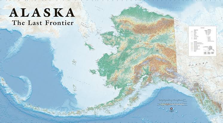
An Alaska map helps travelers, students, and geography enthusiasts understand the enormous scale of America’s largest state. Alaska stretches across mountains, glaciers, forests, tundra, islands, rivers, and thousands of miles of coastline. Because many communities are separated by wilderness or water, viewing the state on a detailed map makes its geography much easier to understand before planning transportation, sightseeing, or outdoor adventures.
Using an Alaska map is especially useful when comparing cities, towns, roads, parks, and major travel regions. Anchorage, Fairbanks, Juneau, Denali National Park, and Southeast Alaska may look relatively close on a small map, yet actual travel distances can be substantial. Some destinations are connected by highways, while others require ferries, airplanes, trains, or boats, making careful geographic planning essential for visitors.
Where Is Alaska Located on the Map?
Alaska is located in the far northwestern portion of North America and is geographically separated from the contiguous United States by Canada. It shares its eastern land border with Canada’s Yukon Territory and British Columbia. The Arctic Ocean lies to the north, while the Pacific Ocean and Gulf of Alaska border much of the state’s southern coastline, giving Alaska an exceptionally diverse geographic setting.
A world Alaska map also shows how close the state lies to Russia. The two countries are separated by the Bering Strait, which creates one of Alaska’s most fascinating geographic relationships. Because Alaska does not directly touch the Lower 48 states, it is commonly displayed in a separate inset on U.S. maps. This presentation can sometimes make Alaska appear smaller than its true enormous size.
Alaska Map With Major Cities and Towns
An Alaska map with cities typically highlights Anchorage, Fairbanks, and Juneau as the state’s three most recognizable urban centers. Anchorage is Alaska’s largest city and a major gateway for tourism, transportation, business, and outdoor travel. Fairbanks serves as an important center in Interior Alaska, while Juneau, located in Southeast Alaska, is the state capital and a popular destination for cruise travelers.
Beyond these major cities, an Alaska map with towns may include Sitka, Ketchikan, Seward, Homer, Kodiak, Palmer, Wasilla, Nome, Bethel, and Utqiagvik. Each community has a different geographic character and transportation network. Unlike many states, Alaska contains numerous towns without direct road connections. Residents and visitors may depend on airplanes, ferries, or boats, particularly in remote coastal and western regions.
Alaska Regions and Geographic Areas
A detailed Alaska map is often divided into several broad geographic and travel regions, including Southcentral, Interior, Southeast, Southwest, and the Far North. Southcentral Alaska includes Anchorage and nearby destinations, while Interior Alaska contains Fairbanks and access toward Denali. Southeast Alaska includes Juneau, Ketchikan, Sitka, and the famous Inside Passage, where forests, mountains, islands, and waterways create dramatic scenery.
Southwest Alaska includes remote coastlines, islands, volcanic landscapes, fisheries, and important wildlife habitats. The Far North stretches toward the Arctic Ocean and contains extensive tundra, isolated communities, and some of the state’s most remote landscapes. Understanding these regions through an Alaska map helps visitors create realistic itineraries, especially because traveling between regions may require flights or other transportation rather than simple highway drives.
Alaska Road Map and Major Highways
An Alaska road map reveals a highway system that is important but less extensive than road networks found in many other states. Major routes include the Alaska Highway, Parks Highway, Glenn Highway, Richardson Highway, Seward Highway, Sterling Highway, and Dalton Highway. These highways connect key communities, scenic areas, national parks, and transportation centers, making them essential for visitors planning independent road trips through accessible parts of Alaska.
The Parks Highway provides an important connection between the Anchorage area and Fairbanks while offering access toward Denali National Park. The Seward Highway leads south from Anchorage toward Seward through spectacular mountain and coastal scenery. Travelers using an Alaska map should remember that fuel stations, restaurants, lodging, and repair services may be widely separated in remote areas, making careful preparation particularly important on longer routes.
Alaska National Parks and Wilderness Areas
An Alaska map featuring national parks reveals some of the most extraordinary protected landscapes in the United States. Denali National Park is especially famous for Denali, the highest mountain in North America. Other major parks include Glacier Bay, Kenai Fjords, Katmai, Lake Clark, Wrangell–St. Elias, Gates of the Arctic, and Kobuk Valley, each offering distinctive landscapes, wildlife, and outdoor experiences.
Accessibility varies greatly between Alaska’s national parks. Some can be approached by highway or railroad, while others may require flights, boats, or specialized transportation. Gates of the Arctic and Kobuk Valley, for example, are extremely remote compared with parks near major travel corridors. A detailed Alaska map helps visitors understand these distances and choose parks that realistically fit their available time, transportation options, and adventure plans.
Alaska Travel Map for Cruises, Ferries, and Trains
An Alaska map designed for travelers should include more than highways because boats, trains, and aircraft play major roles in transportation. Cruise ships frequently visit Southeast Alaska destinations such as Juneau, Ketchikan, Sitka, and Skagway. The Inside Passage is particularly popular because passengers can experience mountains, glaciers, coastal forests, wildlife, and historic communities while traveling through scenic waterways rather than relying on road transportation.
Ferries connect many coastal communities, while the Alaska Railroad provides scenic transportation between important destinations in Southcentral and Interior Alaska. Rail routes can connect travelers with Anchorage, Denali, Fairbanks, Seward, and other areas. Small aircraft are essential for reaching isolated villages, wilderness lodges, and remote parks. These transportation options demonstrate why understanding an Alaska map is critical when building a practical itinerary.
Detailed Alaska Map for Trip Planning
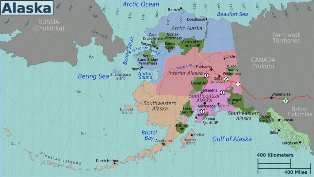
Choosing the right Alaska map depends largely on the type of journey being planned. Road-trip travelers should use updated highway maps showing routes, fuel locations, communities, and major attractions. Cruise passengers benefit from maps showing ports and Southeast Alaska destinations, while hikers and outdoor adventurers may require national park maps, topographic information, trail maps, or detailed regional guides for wilderness navigation.
Travelers should also consider downloading offline maps before leaving major population centers. Cellular coverage can be limited in remote parts of Alaska, and relying entirely on an internet connection may create difficulties. Printable maps can provide useful backup during long drives or wilderness trips. The best Alaska map should clearly display cities, towns, highways, parks, airports, ferry terminals, railroad routes, and important geographic landmarks.
Interesting Alaska Geography Facts
Alaska is the largest U.S. state by area, making its geography unlike anywhere else in the country. Its landscape includes towering mountain ranges, enormous glaciers, wide river systems, tundra, coastal rainforests, volcanic islands, and extensive wilderness. An Alaska map also reveals the Aleutian Islands stretching far westward into the North Pacific, demonstrating how unusually broad the state is from east to west.
Denali rises within the Alaska Range and represents one of the state’s most recognizable natural landmarks. Northern Alaska reaches above the Arctic Circle, while Southeast Alaska contains a dramatically different environment filled with temperate coastal forests and narrow waterways. These geographic contrasts explain why weather, scenery, wildlife, and transportation can vary significantly between regions, even within the same state.
Conclusion
An Alaska map provides an essential overview of a state where geography influences almost every aspect of travel. Cities such as Anchorage, Fairbanks, and Juneau are separated by large distances and different transportation systems, while national parks, highways, islands, and wilderness areas spread across an enormous landscape. Understanding these relationships can help travelers avoid unrealistic itineraries and choose routes that match available transportation.
Whether you are planning a road trip, cruise, national park adventure, or educational project, a detailed Alaska map makes the state easier to explore. It can reveal major cities, small towns, roads, parks, regional boundaries, railways, ferry routes, and geographic landmarks. With careful map planning, visitors can better appreciate Alaska’s extraordinary scale while creating a safer and more enjoyable journey through the Last Frontier.
FAQs
Where is Alaska located on the map?
Alaska is located in northwestern North America. It borders Canada to the east, the Arctic Ocean to the north, and Pacific waters to the south and west.
What are the major cities on an Alaska map?
Anchorage, Fairbanks, and Juneau are the most prominent cities. Other notable communities include Ketchikan, Sitka, Wasilla, Palmer, Homer, Seward, Kodiak, Nome, and Bethel.
Can you drive to every city in Alaska?
No. Many communities are not connected to Alaska’s highway system. Travelers often need airplanes, ferries, boats, or other transportation to reach remote towns and coastal destinations.
Where is Denali on an Alaska map?
Denali is located in the Alaska Range within Denali National Park and Preserve. The park lies in Interior Alaska between the Anchorage and Fairbanks regions.
What are the main highways in Alaska?
Important routes include the Alaska Highway, Parks Highway, Glenn Highway, Richardson Highway, Seward Highway, Sterling Highway, and Dalton Highway.
What is the best Alaska map for travelers?
The best option depends on the trip. Road travelers should use a highway map, while cruise visitors, hikers, and national park travelers may need specialized regional or transportation maps.
You May Also Read: When Is Mexico Independence Day