

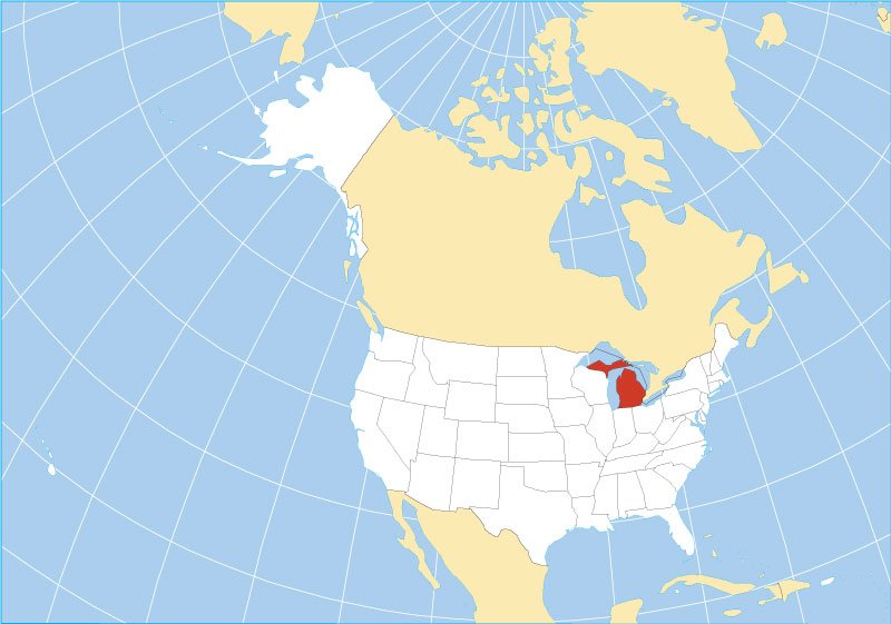
A Michigan map gives readers a clear picture of one of the most geographically distinctive states in the United States. Michigan is divided into two major land areas known as the Upper Peninsula and Lower Peninsula. Surrounded by four of the five Great Lakes, the state includes large metropolitan areas, smaller towns, forests, beaches, highways, rivers, and extensive shorelines that shape everyday travel and regional identity.
Understanding the Michigan map is useful for travelers, students, new residents, and anyone studying American geography. Major destinations such as Detroit, Grand Rapids, Lansing, Ann Arbor, Traverse City, and Marquette are spread across different regions. Because Michigan covers a large area and contains two separate peninsulas, knowing where cities, towns, roads, and highways are located can make trip planning and navigation much easier.
Where Is Michigan Located?
Michigan is located in the Midwestern United States and forms an important part of the Great Lakes region. The Lower Peninsula is bordered by Indiana and Ohio to the south, while Wisconsin borders part of the Upper Peninsula. Michigan also shares international boundaries with Canada through waterways. Its unusual position among the Great Lakes gives the state a recognizable shape and makes water one of its defining geographic features.
A detailed Michigan map shows Lake Michigan along the western side of the Lower Peninsula and Lake Huron along much of the eastern shoreline. Lake Superior borders the northern Upper Peninsula, while Lake Erie touches southeastern Michigan. The Straits of Mackinac separate the two peninsulas. This location has influenced Michigan’s transportation networks, economy, tourism industry, climate, recreational opportunities, and development of communities throughout the state.
Michigan Map With Major Cities and Towns
A Michigan map with cities highlights several important population centers, beginning with Detroit in the southeastern part of the state. Detroit is Michigan’s largest city and sits close to the Canadian border. Grand Rapids is a major city in western Michigan, while Lansing serves as the state capital. Ann Arbor, Flint, Dearborn, Warren, Kalamazoo, Sterling Heights, and Livonia are other notable communities throughout the Lower Peninsula.
Northern Michigan and the Upper Peninsula contain smaller cities and towns that are equally important for tourism and regional life. Traverse City is a popular destination in the northern Lower Peninsula, while Marquette is one of the best-known cities in the Upper Peninsula. Other places commonly found on a Michigan map include Sault Ste. Marie, Escanaba, Houghton, Mackinaw City, Muskegon, Battle Creek, Saginaw, Alpena, and Petoskey.
Michigan Roads and Major Highways
Michigan has an extensive road system that connects metropolitan areas, rural communities, tourist destinations, and neighboring states. A Michigan road map is particularly useful because distances between major destinations can be substantial. Interstate 75 is one of the state’s most important highways, running through southeastern Michigan and continuing north toward the Mackinac Bridge before entering the Upper Peninsula and reaching the Canadian border near Sault Ste. Marie.
Other major highways include I-94, which crosses southern Michigan through areas including Detroit, Ann Arbor, Kalamazoo, and Battle Creek. I-96 connects Detroit with Lansing and Grand Rapids, while I-69 serves several communities through the central and eastern portions of the state. Routes such as I-196, I-275, and I-696 support regional transportation. US highways and state routes provide additional connections to smaller towns, lake communities, and recreational areas.
Upper Peninsula and Lower Peninsula Map
The Lower Peninsula is immediately recognizable because its outline resembles a mitten. Most of Michigan’s population lives in this part of the state, including residents of Detroit, Grand Rapids, Lansing, Ann Arbor, Flint, and Kalamazoo. The region includes agricultural areas, industrial centers, inland lakes, and popular Lake Michigan destinations. A Lower Michigan map is especially helpful for understanding the relationship between metropolitan areas, highways, and northern vacation communities.
The Upper Peninsula has a very different geographic character. It contains expansive forests, rocky shorelines, waterfalls, mining communities, and long stretches of sparsely populated land. Marquette, Escanaba, Houghton, Iron Mountain, and Sault Ste. Marie are among its better-known communities. Travelers moving between Michigan’s two peninsulas generally cross the Mackinac Bridge, an important transportation connection spanning the Straits of Mackinac between Mackinaw City and St. Ignace.
Michigan Counties and Regional Areas
Michigan is divided into 83 counties, and a Michigan county map helps users understand local boundaries beyond the major cities. Wayne County includes Detroit and surrounding communities, while Oakland and Macomb counties are important parts of the larger Detroit metropolitan area. Kent County includes Grand Rapids, Ingham County contains Lansing, and Washtenaw County includes Ann Arbor. Each county contains its own mixture of cities, townships, villages, and rural areas.
County maps are useful for more than basic geography. Residents may use them when researching property, government services, school districts, local travel, or community boundaries. Travelers can also use county information to understand the transition between different regions. Northern counties tend to be less densely populated than southeastern Michigan, while many western counties contain communities along Lake Michigan. The Upper Peninsula includes large counties where towns may be separated by considerable distances.
Michigan Great Lakes and Natural Geography
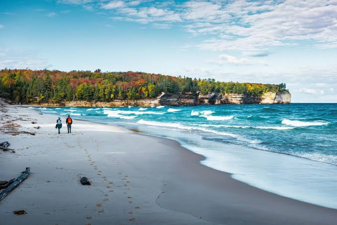
The Great Lakes dominate Michigan’s geography and are easy to recognize on nearly every Michigan map. Michigan touches Lakes Superior, Michigan, Huron, and Erie, giving the state an extraordinary relationship with freshwater. These lakes influence transportation, recreation, tourism, weather, settlement patterns, and local economies. Countless beaches, harbors, islands, lighthouses, and waterfront communities have developed along Michigan’s extensive Great Lakes coastline over generations.
Michigan also contains thousands of inland lakes, numerous rivers, forests, wetlands, and protected natural areas. The Upper Peninsula is especially known for rugged landscapes and forested terrain, while the Lower Peninsula includes farmland, rolling countryside, urban regions, and lakefront communities. Physical maps often display these natural features more clearly than standard road maps. They can help travelers understand why Michigan offers such varied scenery despite being one single state.
Using a Michigan Map for Travel and Road Trips
A Michigan map can be extremely valuable when planning a road trip because popular attractions are spread across a wide geographic area. Travelers beginning in Detroit might visit Ann Arbor before continuing toward Lansing or Grand Rapids. Those interested in Lake Michigan can explore western communities, while visitors heading north may travel toward Traverse City, Mackinaw City, or the scenic areas surrounding the northern Lower Peninsula.
A longer road trip can continue across the Mackinac Bridge into the Upper Peninsula, where destinations are more widely separated. Travelers may explore Marquette, Pictured Rocks National Lakeshore, Sault Ste. Marie, or communities near Lake Superior. Using a Michigan highway map alongside an interactive navigation tool can help visitors compare routes, estimate distances, and identify alternative roads. Seasonal weather should also be considered, particularly when traveling through northern Michigan during winter.
Different Types of Michigan Maps
Different types of maps serve different purposes. A Michigan highway map focuses primarily on interstates, US highways, state routes, and connections between cities. A city map provides more detailed information about streets and neighborhoods, while a county map emphasizes administrative boundaries. Physical maps highlight terrain, lakes, rivers, and other natural features. Choosing the right map depends on whether the user is traveling, studying geography, researching communities, or planning a move.
Interactive maps are particularly useful because users can zoom into individual roads, towns, businesses, attractions, and neighborhoods. Printable maps remain valuable for classrooms, presentations, offline travel planning, and quick geographic reference. Tourism maps may emphasize beaches, parks, historic sites, and recreational destinations. Combining several map types often provides the most complete understanding of Michigan, especially when exploring both populated southern areas and more remote northern regions.
Conclusion
A Michigan map provides a useful visual guide to the state’s cities, towns, roads, highways, counties, Great Lakes, and regional differences. Michigan’s two-peninsula layout creates a unique geographic structure that can sometimes make distances and travel routes difficult to understand without a map. From Detroit and Grand Rapids to Traverse City and Marquette, each region contributes something different to the state’s character and transportation network.
Whether you are planning a vacation, studying geography, relocating, or simply exploring unfamiliar destinations, the right Michigan map can make the process easier. Road maps help with driving, city maps provide local detail, and physical maps reveal Michigan’s natural landscape. By understanding the relationship between highways, cities, peninsulas, counties, and lakes, travelers can navigate Michigan more confidently and appreciate the remarkable geography that defines the Great Lakes State.
Frequently Asked Questions
Where is Michigan located on the US map?
Michigan is located in the Midwest and Great Lakes region of the United States. It borders Wisconsin, Indiana, and Ohio and shares water boundaries with Canada.
What are the major cities on a Michigan map?
Major cities include Detroit, Grand Rapids, Warren, Sterling Heights, Ann Arbor, Lansing, Flint, Dearborn, Kalamazoo, and several other important regional communities.
What are the main highways in Michigan?
Important Michigan highways include I-75, I-94, I-96, I-69, I-196, I-275, and I-696, along with numerous US highways and state routes.
How many counties are shown on a Michigan county map?
Michigan has 83 counties distributed across its Lower and Upper Peninsulas, ranging from densely populated metropolitan counties to large rural northern counties.
What connects Michigan’s Upper and Lower Peninsulas?
The Mackinac Bridge connects the Upper and Lower Peninsulas by crossing the Straits of Mackinac between St. Ignace and Mackinaw City.
You May Also Read: Jannik Sinner Age