

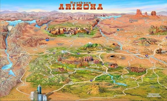
A map can reveal much more than borders and highways; it can tell the story of how a place grows, changes, and connects people. The Arizona map has become increasingly important as the state experiences population growth, expanding cities, water challenges, tourism development, and major infrastructure changes. From the desert landscapes of Phoenix and Tucson to the forests of Flagstaff and the dramatic cliffs of the Grand Canyon, Arizona’s geography shapes nearly every part of life.
Over the past several decades, Arizona has transformed from a primarily agricultural and mining-focused region into one of the fastest-growing states in the United States. Understanding its regions, counties, transportation networks, and natural landmarks helps residents, businesses, travelers, and researchers better understand the opportunities and challenges facing the Southwest.
Understanding Arizona’s Geography Through Maps
The Arizona map provides a visual explanation of the state’s unique geography. Located in the southwestern United States, Arizona shares borders with California, Nevada, Utah, Colorado, New Mexico, and the Mexican state of Sonora. Its location places it at the intersection of major economic, cultural, and transportation routes.
Arizona covers approximately 113,990 square miles, making it the sixth-largest state by land area in the country. Despite its reputation as a desert state, its geography is remarkably diverse. The state includes deserts, mountains, forests, plateaus, canyons, and volcanic landscapes. This variety creates different climates and ecosystems across its regions.
The Sonoran Desert dominates much of southern Arizona, while northern areas feature the Colorado Plateau and high-elevation forests. This geographic diversity explains why Arizona can have hot desert temperatures in Phoenix while receiving winter snowfall in Flagstaff. A detailed map helps people understand these dramatic environmental differences.
Major Cities and Regions Shown on Arizona Map
One of the most important uses of an Arizona map is understanding the relationship between its major cities and regions. Phoenix, the state capital and largest city, has become a major center for technology, manufacturing, healthcare, and finance. The Phoenix metropolitan area continues attracting new residents and businesses because of its economic growth and investment opportunities.
Tucson, located in southern Arizona, has a different identity shaped by education, aerospace research, and cultural heritage. Home to the University of Arizona, the city has developed strong connections with science, astronomy, and innovation. Meanwhile, northern communities such as Flagstaff provide access to forests, outdoor recreation, and scientific research facilities.
Other important areas include Mesa, Scottsdale, Tempe, Yuma, and Prescott. Each region contributes differently to Arizona’s economy and culture. A regional view helps explain why the state cannot be defined only by desert landscapes or major urban centers.
Counties and Administrative Regions Across Arizona
The Arizona map highlights 15 counties, each with different economic strengths, landscapes, and community characteristics. Maricopa County, which includes Phoenix, is the most populated county and one of the fastest-growing urban areas in the United States.
Pima County, home to Tucson, has a strong educational and research presence, while Coconino County covers a large northern territory containing the Grand Canyon and extensive forest areas. These county differences influence everything from transportation planning to public services.
Rural counties play an important role as well. Areas such as Navajo County, Apache County, and Mohave County contribute through tourism, energy production, agriculture, and natural resources. Understanding county boundaries helps policymakers plan infrastructure, healthcare access, education programs, and economic development strategies.
Arizona’s Natural Landmarks and Geographic Diversity
The natural features shown on an Arizona map are among the most recognizable landscapes in the world. The Grand Canyon remains the state’s most famous attraction, drawing millions of visitors annually and representing one of Earth’s greatest geological formations.
Beyond the Grand Canyon, Arizona includes Monument Valley, Petrified Forest National Park, Saguaro National Park, and the red rock landscapes around Sedona. These destinations support a major tourism economy while protecting unique ecosystems and cultural heritage sites.
The state’s geography also includes important rivers and water systems. The Colorado River, Salt River, and Gila River have historically supported agriculture, cities, and ecosystems. However, long-term drought conditions and water supply concerns have made water management one of Arizona’s most important planning issues.
Transportation Networks and Infrastructure Growth
Transportation routes are a major feature displayed on an Arizona map. Interstate highways such as I-10, I-17, and I-40 connect major cities and support regional trade. These routes are essential for moving goods, supporting tourism, and connecting communities across large distances.
As Arizona’s population grows, transportation infrastructure has become a major focus for government agencies and planners. The expansion of highways, public transit systems, and airport facilities reflects the state’s increasing economic importance.
Phoenix Sky Harbor International Airport has become one of the busiest airports in the United States, supporting tourism and business connections. Meanwhile, improved road networks are helping smaller communities access larger economic centers.
Future transportation planning will likely focus on sustainability, electric vehicle infrastructure, and smart technology. Geographic data and digital mapping tools will continue playing a major role in identifying transportation needs.
Population Growth and Urban Expansion in Arizona
Population growth is one of the biggest stories connected to the Arizona map. Arizona has experienced significant population increases due to migration, economic opportunities, and a growing technology sector. The Phoenix metropolitan area has become a major destination for people seeking employment and a lower cost of living compared with some coastal cities.
This growth has created both opportunities and challenges. New housing developments, business districts, and infrastructure projects are expanding urban areas. However, rapid growth also creates pressure on water resources, transportation systems, and public services.
Experts studying southwestern development emphasize the importance of sustainable planning. Cities must balance economic expansion with environmental protection and responsible resource management.
The changing population patterns also influence political representation, education needs, and regional planning decisions. Maps help visualize where growth is occurring and where future investments may be required.
Technology, Mapping Tools, and Modern Arizona Planning
Modern geographic technology has transformed how people use maps. Today’s digital Arizona map resources provide interactive information about roads, weather conditions, land use, population trends, and environmental changes.
Geographic Information Systems (GIS) are now used by government agencies, businesses, scientists, and emergency planners. These systems combine geographic data with information analysis to improve decision-making.
For example, GIS technology helps manage wildfire risks, monitor drought conditions, plan construction projects, and protect natural resources. Arizona’s complex environment makes accurate geographic information especially valuable.
Technology companies and research institutions are also developing advanced mapping solutions using artificial intelligence and satellite data. These tools can provide faster insights into changing landscapes and help communities prepare for future challenges.
Tourism and Economic Importance of Arizona Regions
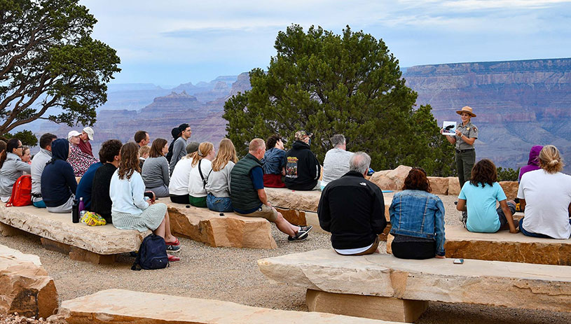
Tourism remains one of Arizona’s strongest economic sectors. Visitors use an Arizona map to plan trips across national parks, historic towns, outdoor recreation areas, and cultural attractions.
The Grand Canyon attracts millions of visitors every year, but tourism extends far beyond this single destination. Sedona’s red rocks, Scottsdale’s resorts, Tucson’s cultural festivals, and northern Arizona’s forests create diverse travel experiences.
Outdoor recreation has become increasingly important as travelers seek hiking, camping, mountain biking, and nature-based experiences. This trend has encouraged investment in trails, conservation programs, and visitor services.
Arizona’s economy has also expanded beyond tourism. Semiconductor manufacturing, renewable energy, aerospace, and technology industries are becoming major contributors. Companies are choosing Arizona because of its workforce, infrastructure, and strategic location.
Water Challenges and Environmental Changes
A major issue visible through any Arizona map is the relationship between human development and limited water resources. Arizona’s desert environment requires careful water management, especially as cities continue growing.
The Colorado River has historically supported millions of people across the Southwest, but drought conditions and climate change have created increasing concerns about future water availability. Arizona has invested in conservation programs, infrastructure improvements, and new water management strategies.
Agriculture remains an important part of the state’s economy, particularly in areas producing cotton, vegetables, and livestock. However, farmers and communities are adapting to changing conditions through improved irrigation technology and resource planning.
Environmental experts suggest that future development will depend on balancing population growth with sustainable water use. Geographic planning will remain essential for making informed decisions.
Historical Development and Cultural Identity of Arizona
The story behind the Arizona map is connected to thousands of years of human history. Indigenous communities, including the Navajo Nation, Hopi Tribe, Tohono O’odham Nation, and other Native peoples, have maintained deep cultural connections to the land for generations.
Arizona became the 48th state of the United States on February 14, 1912. Since then, its identity has been shaped by mining, agriculture, military development, tourism, and technology.
Historic routes, old mining towns, and Native cultural sites continue influencing Arizona’s modern character. Places such as Bisbee, Jerome, and Tombstone preserve stories from earlier periods.
Understanding history through geography helps explain why different parts of Arizona developed unique identities. Maps provide a connection between past communities and present-day growth.
Future Trends Shaping Arizona’s Geographic Landscape
The future of Arizona will likely be influenced by technology, renewable energy, climate adaptation, and continued population growth. The way communities develop will determine how effectively the state manages resources and opportunities.
Solar energy expansion is becoming increasingly important because Arizona receives abundant sunlight throughout the year. Renewable energy projects, battery storage systems, and clean technology investments may reshape parts of the state’s economic landscape.
Urban planners are also focusing on smarter cities, water conservation, and efficient transportation. Future digital mapping systems will provide more detailed information to support these decisions.
As Arizona continues evolving, geographic awareness will become even more valuable. Understanding regional differences allows communities to prepare for future challenges while protecting the state’s unique environment.
Key Takeaways
- The Arizona map reveals a state with deserts, forests, mountains, cities, and diverse ecosystems.
- Arizona’s population growth is creating new economic opportunities and planning challenges.
- Major cities such as Phoenix and Tucson drive innovation, education, and business development.
- Water management remains one of the state’s most important future concerns.
- Digital mapping technology helps improve transportation, conservation, and emergency planning.
- Tourism, technology, renewable energy, and manufacturing are shaping Arizona’s future economy.
Conclusion
The Arizona map is more than a geographic guide; it is a reflection of a state experiencing dramatic transformation. From ancient Indigenous landscapes to modern technology hubs, Arizona’s regions tell a story of adaptation and growth.
As population trends, climate challenges, and economic opportunities continue changing the Southwest, understanding Arizona’s geography will become increasingly important. Whether exploring national parks, planning a move, studying business opportunities, or researching regional development, geography provides the foundation for understanding the state.
Arizona’s future will depend on thoughtful planning, responsible resource management, and continued innovation. Explore the state’s regions, landmarks, and communities to discover how geography continues shaping one of America’s most dynamic states.
Frequently Asked Questions
What does an Arizona map show?
An Arizona map shows cities, counties, highways, natural landmarks, borders, rivers, and geographic regions across the state.
How many counties are in Arizona?
Arizona has 15 counties, each with different landscapes, communities, and economic characteristics.
What are the biggest cities on the Arizona map?
Phoenix, Tucson, Mesa, Chandler, Scottsdale, and Glendale are among Arizona’s largest cities.
Why is Arizona famous for its geography?
Arizona is famous for deserts, mountains, the Grand Canyon, forests, and unique southwestern landscapes.
How is Arizona managing water challenges?
Arizona uses conservation programs, improved infrastructure, and planning strategies to manage limited water resources.
What industries are growing in Arizona?
Technology, semiconductor manufacturing, renewable energy, aerospace, tourism, and healthcare are growing industries in Arizona.
You May Also Read: Afrikaans