

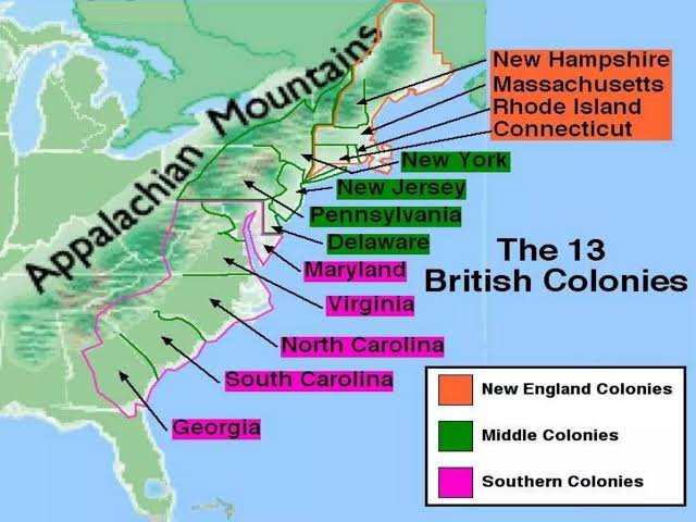
The Middle Colonies Map helps readers visualize the central region of colonial America and understand how geography influenced the growth of early settlements. This historical map highlights the location, boundaries, and importance of colonies that became essential to trade, farming, and cultural development.
Exploring the Middle Colonies Map provides a clearer picture of how New York, New Jersey, Pennsylvania, and Delaware developed during the colonial period. These colonies connected different parts of British America and played a major role in shaping the economy and society of the thirteen colonies.
What Are the Middle Colonies?
The Middle Colonies were four British colonies located between the New England Colonies and the Southern Colonies. These colonies included New York, New Jersey, Pennsylvania, and Delaware, each with unique geographic features and historical contributions that influenced colonial America.
The region became known for its productive farmland, growing cities, and diverse population. Unlike many other colonial areas, the Middle Colonies attracted settlers from different countries and religious backgrounds, creating a multicultural environment that helped the region expand.
Middle Colonies Map: States and Locations Explained
The Middle Colonies Map shows the exact locations of the colonies that formed this important region. New York was located in the northern part of the region and became a major trading center because of its coastal position and valuable harbor.
Pennsylvania, New Jersey, and Delaware also held important positions on the map. Pennsylvania became famous for Philadelphia and agricultural success, while New Jersey and Delaware contributed through farming, transportation routes, and connections between larger colonial communities.
Geography of the Middle Colonies
The geography shown on the Middle Colonies Map explains why this region became one of the most successful areas in colonial America. The colonies had fertile soil, rivers, forests, and coastal areas that supported farming, transportation, and settlement growth.
The moderate climate allowed farmers to grow crops such as wheat, corn, and rye. Because of their agricultural production, the Middle Colonies became known as the “breadbasket colonies,” supplying food to other regions and supporting economic development.
Economy and Trade in the Middle Colonies
The economy of the Middle Colonies was strongly connected to the geographic advantages visible on the Middle Colonies Map. Farming was the main economic activity, but trade, manufacturing, and shipping also helped the colonies become prosperous.
Major cities like Philadelphia and New York developed into important commercial centers. Their ports allowed merchants to exchange goods with other colonies and overseas markets, making the Middle Colonies an important part of the colonial economy.
People, Culture and Religion in the Middle Colonies
The Middle Colonies were known for their cultural and religious diversity. The Middle Colonies Map represents a region where different groups settled and created communities with various traditions, languages, and beliefs.
Pennsylvania was especially recognized for religious freedom under William Penn’s leadership. Quakers, Germans, Dutch settlers, and English immigrants all contributed to the unique identity of the region, making it one of the most diverse areas in colonial America.
The Middle Colonies and the Thirteen Colonies
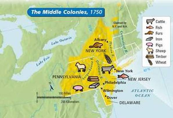
The Middle Colonies Map is an important part of understanding the larger thirteen colonies system. Positioned between the northern and southern regions, the Middle Colonies served as a bridge connecting different colonial economies and communities.
Their central location gave them political and economic importance. The colonies contributed resources, ideas, and leaders who influenced the events that eventually led to the creation of the United States.
How to Read a Middle Colonies Map
A Middle Colonies Map can help students and history readers understand important geographic details from the colonial era. Historical maps often show colony borders, major cities, rivers, and transportation routes that influenced settlement patterns.
When studying the map, readers should focus on how geography affected daily life. Rivers supported transportation, fertile land encouraged farming, and coastal locations helped colonies develop stronger trade networks.
Interesting Facts About the Middle Colonies
The Middle Colonies had many features that made them unique compared with other colonial regions. The Middle Colonies Map shows an area where agriculture, trade, and cultural exchange developed together.
Philadelphia became one of the most influential cities in colonial America, while New York grew as a major commercial center. The combination of natural resources, economic opportunities, and cultural diversity helped the Middle Colonies become a powerful region.
Conclusion
The Middle Colonies Map provides a valuable way to understand the geography and history of colonial America. By exploring New York, New Jersey, Pennsylvania, and Delaware, readers can see how location shaped economic growth, settlement patterns, and cultural development.
The Middle Colonies were an important foundation of early American history because they combined agricultural success, trade opportunities, and diverse communities. Studying this region through maps allows students and history enthusiasts to better understand the development of the thirteen colonies.
FAQs
What does the Middle Colonies Map show?
The Middle Colonies Map shows the locations, boundaries, and important geographic features of the Middle Colonies during the colonial period.
Which colonies were included in the Middle Colonies?
The Middle Colonies included New York, New Jersey, Pennsylvania, and Delaware.
Why were the Middle Colonies important?
The Middle Colonies were important because they supported farming, trade, cultural diversity, and economic development.
Where were the Middle Colonies located?
The Middle Colonies were located between the New England Colonies and Southern Colonies in British America.
What was the main economy of the Middle Colonies?
The economy of the Middle Colonies was based on agriculture, trade, shipping, and skilled industries.
You May Also Read: PPL@Home